Walk 12 - The Knapp or Elephant Walk
Knapp and Papermill Nature Reserve
Introduction
This nature reserve is one of 70 nature reserves owned and run by the Worcestershire Wildlife Trust. This magnificent 67 acre nature reserve provides a fascinating mix of habitats which include hay meadows, a lush valley, a brook, stream, river or torrent depending upon the time of year, woodland and a wonderful catalogue of plants.
An interesting historical reference to the Knapp rather bizarrely concerns an elephant!
The Knapp Papermill buildings were home to a travelling circus back in the days when a circus travelled on ‘foot’ from town to town. Sadly one of the elephants died either of old age or starvation (or both). Given its size it was impossible to dispose of it anywhere else but to bury it where it fell. So somewhere near the entrance to the Knapp are the remains of an elephant!
So if you have a dog with you, don’t let it start digging for bones as they may be too big to take home!
Summary
A secluded meadow, streamside and woodland walk tucked away in the Leigh Brook Valley. This circular walk of two miles is for nature lovers and follows most of the Wildlife Trust’s suggested route as well as including a section of public footpath to Millham Farm before returning downhill to the car park. This nature reserve is well managed and sports an observation hut for Kingfishers, old hay meadows, a trout stream and woodland. The paths are well marked but can be muddy in places. The walk is two miles which will take just under the hour without breaks and has a gentle climb of just 290 feet.
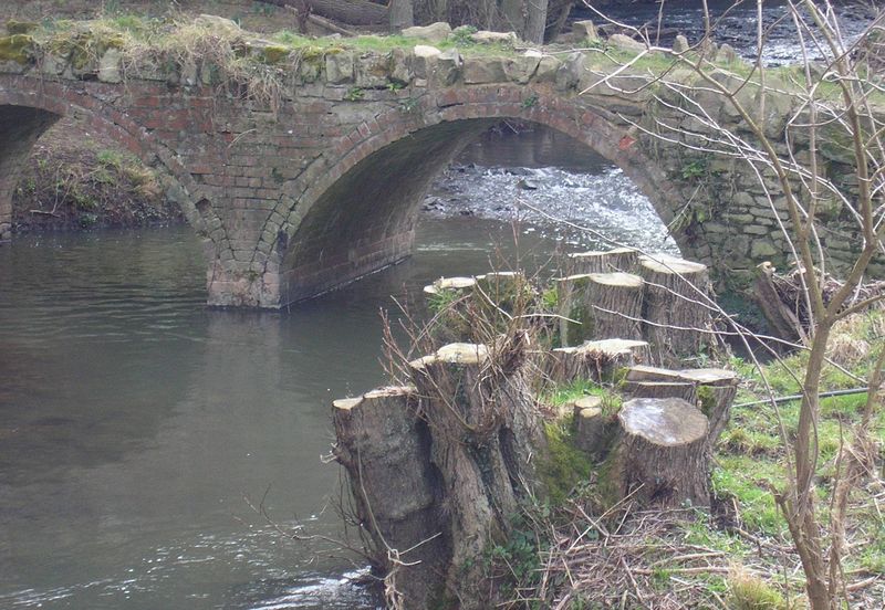
From the Worcester to Hereford Road (A4103) enter the 30 mile speed limit of Leigh Sinton, note the Hereford end of the village has speed cameras. On the right (west) past a row of lockups is a signposted turning for Suckley. But if approaching from Hereford the signpost is hardly visible. Take this twisting country lane past the Memorial Hall at Smith End, do not turn off until the T junction is reached. At the T junction, turn left for Suckley. This lane is just as narrow, so take care with oncoming traffic. Do not turn off at any of the junctions and 2 miles on the left hand side heading down into a valley is a signpost, ‘Old Storridge No through Road’, apply the brakes and on the right there is plenty of car parking space in the lay-bye. If you miss this opportunity continue over the stone bridge and venture to the entrance of the Knapp Nature Reserve where there is a small parking area just above the bridge. The entrance may be locked at 6 pm each day. Map reference SO 75099 52161. Postcode WR6 5HR. Further up the road is Alfrick Pound, a tiny hamlet of just a few cottages.
Looking back from the entrance next to the information board, the stone bridge is an elegant sturdy affair. Note the recent works to the bank to stop the road being washed away by this apparently gentle flowing brook which in times of precipitation can turn into a raging torrent. The original bridge and mill in the nature reserve which is called Gunwick Papermill (the Papermill Cottage is all that remains) was washed away by a twenty foot flood in 1852.
Head through the sturdy wooden gate next to the information board at the top end of the small car park and into a small open shaded area with wooden picnic seats. This has been developed as a ‘mustering’ place for the groups of school children who regularly visit. Outside of the school day it is a lovely area in which to enjoy a picnic. The first path to the right leads up to the ‘conference centre’ and toilets. The path straight on heads to the Knapp Cottage and Wardens House where there is a substantial reception area and a visitors centre with local guide books for sale.
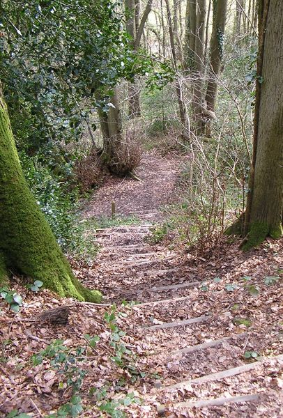
The walk commences through the gate into what appears to be a delightful private country garden and runs parallel to Stocks Road as it heads up to Alfrick Pound. A five-barred gate to the right gives the warden vehicle access to the reserve as the broad track now heads downhill through the woods towards the brook. Ahead is a five-barred metal gate and next to it a wooden gate with a small No 1 painted in red, indicating the first point in the Nature Reserve walk. This leads into an old apple orchard where sheep can be found grazing.
There are several paths through the orchard, however keeping left the path meanders alongside the brook towards the weir. In the brook are small brown trout and darting about with their erratic flight path dragonflies along the steep banks during the summer months. Following the brook through Daffodil Meadow the name comes from the fact that daffodils used to be commercially grown here.
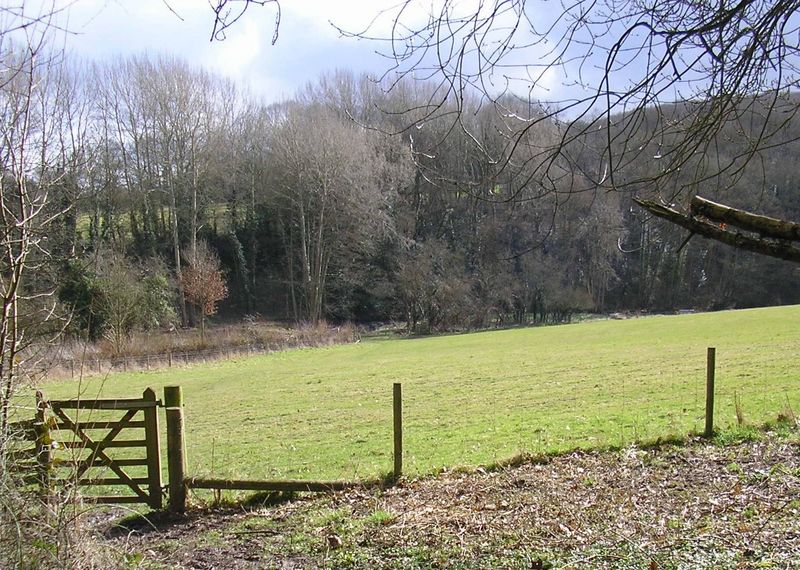
Follow the brook through the meadow, the next gate is marked No 5, at Pivany Bridge now leads into The Big Meadow formally known as Great Epiphany because the rent was due each year on Epiphany Day the 6th of January. With the broad and expansive meadow to the right the path which can be a little muddy in places follows the bank of the Leigh Brook. Passing through the next gate the path enters a shaded woodland section. A little further on across the brook, a cottage can be seen and a quite sturdy wooden bridge.
The path now climbs up towards a kissing gate (number 6 on the nature reserve map) to the right of the five-barred gate. The path cuts the corner off the bend of the brook and leads to Papermill Cottage which is the only reminder of Gunwick Mill. Interesting to note the historical reference from Edwin Lees book ‘Pictures of Nature of 1856’ as a ‘little depressed Welshman, struggling with poverty and a large family, tried to make a living by manufacturing a very coarse cap-paper. The poor fellow had a long way to take his paper to purchasers by bad roads in a groaning, rickety, yawning cart drawn by a stumbling half-starved horse. He eventually gave up and moved to Australia and the mill fell to pieces and no one cared to rebuild it’. The assumption is that the remains of the mill were swept away in the flood of 1852.
The cottage is fenced off and during the winter months when the weeds and flowers have died back a well can be seen towards the front of the cottage. Continue to the next gate marked number 8, map reference SO 74332 51508. Do not go through the gate which is the continuation of the public footpath which is also designated as the GeoPark Way, but head right, uphill with the field boundary to the left. The path continues around the top section of the field with woods to the left. The number 9 signpost continues the circumnavigation of the woods on this higher ground. Follow the fence as more uphill is encountered and is marked number 10. Looking back to the brook the splendour of the deep valley can be appreciated and in summer the full extent of the range of the different shades of green on the trees, meadow and fields fills ones vision. The kissing gate is marked number 11 on the map at map reference SO 74521 51587, leads into the woods known as Tor Coppice and shortly after a signboard provides a map and directions to the nature reserve. A detour to this walk is to carry straight on, ignoring the yellow marked route to the right. The detour follows the path keeping the fence with open fields to the left and an old hut comes into view on the right. Apparently this was used in the past by scouts and cubs and a little further on amongst the trees is a rusting metal wheeled trailer.
Returning to the signboard follow the signposted route through the coppice where during spring an abundance of wild garlic and bluebells adorn the woodland floor. Look out for the unusual black painted bird box’s set amongst the trunks of the trees, A guess at the colour suggests that school parties and visitors can quickly identify the nesting birds. The path now starts to descend towards The Big Meadow and a set of steps reminds the knee joints that walking downhill is not as preferable as going uphill! The number 12 signpost points through the edge of the woods. At number 13 our route is not to follow the return leg to the warden’s cottage but to head downhill to the corner of the expansive Big Meadow. The view across the meadow is stunning. If I was between 6 and 10 years of age I might now open my arms and make an aeroplane noise, run down the rolling meadow towards the brook. If I was sure no one was looking, I probably would still dare to do this!
With the hedgerow to the left Pivany Bridge is soon reached. Go through the gate and cross over this delightful stone bridge. To the left is the public footpath. During the summer it can be rather overgrown, fortunately with not too many stingers or brambles. Head up to the edge of the copse where over the centuries the brook in full flood has carved out the sweeping bend and up to a five-barred metal gate marked the ‘End of Nature Reserve’. Map reference SO 74962 51910. Across the field Millham Farm can be seen, the footpath heads in the general direction of the farm towards the five barred gate on the opposite side of the field. To the left is a pear and apple orchard with a modern wooden structure that appeared a few days before this guide went to print. The next section of the footpath is just a few steps towards the farm buildings and then a left through another gate. The farmer’s cottage garden is to the right and very shortly another gate has to be opened. This leads into a sweeping downwardly sloping field with a stile in the stonewall. To the left next to the brook are the buildings of Bridges Stone Mill where the travelling circus was based.
Once over the stile it is just a short walk back to a gate adjacent to Stocks Road and over Bridges Stone Bridge, built in 1936, where in the centre of the arch there is an acknowledgement to BC Hammond, County Surveyor and Bridge Master. Do note the red face of the Triassic sand dunes on the opposite side of the road. With this last flourish of local history, this concludes this delightful scenic circular tour of the Knapp Nature Reserve.
This is an abridged version of a walk from Book Four: A Pictorial Guide to the Malvern Hills, published by Malvern Walks at £7.95.
Available in local bookshops like the Malvern Book Co-operative (2 St Anne's Road, Malvern) and Tourist Information Centres in Malvern, Upton Upon Severn, Ledbury, Worcester.