Walk 10 - A Walk with Medieval Spirit
Hollybush to Eastnor Castle returning via the Ridgeway Path
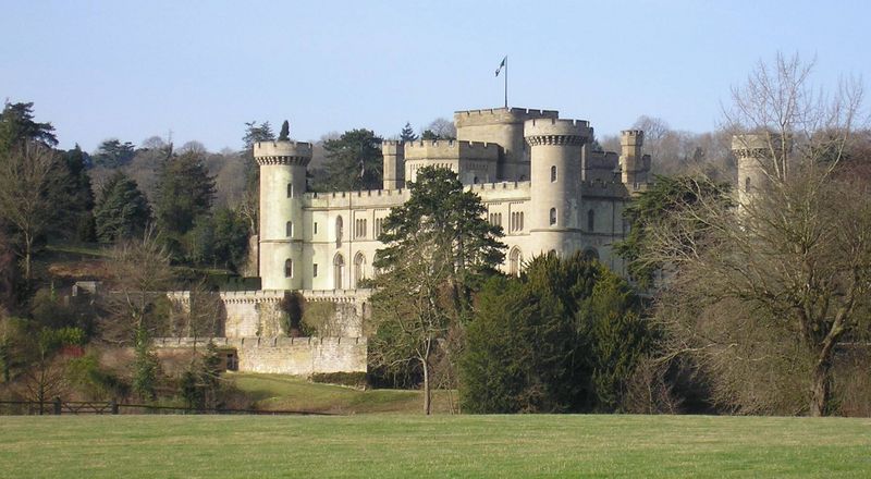
This is a scenic 7 and a half mile circular walk captures the spirit of medieval chivalry and romance with the fairytale Eastnor Castle, a Georgian folly of an authentic motte castle built by the Earl Somers in 1812. The walk passes the impressive Obelisk and visits the 17th century St John the Baptist Church. Allow three and half hours without refreshment breaks.
Start this walk from the Conservators car park in the tiny hamlet of Hollybush which is just a couple of delightful cottages located near the brow of the hill on the A438 Ledbury to Tewkesbury Road. There is a bus stop for the 388 and 671 services on the opposite side of the road from the car park, map reference SO 7589 3689. Do take extra caution when driving around Castlemorton and Hollybush Commons, any of the roads can be made temporarily impassable by large herds of cows or sheep.
Take a moment to read the local Information Board. The route to the Obelisk crosses a cattle grid and heads up the hill. Pollarded Willows can be seen on the left and further in the distance through the Hawthorne bushes the first glimpse of the fairytale Eastnor Castle. Our route is signposted ‘The Three Counties Way and Geopark Way’. The lane reverts to more humble origins and across the valley to the left where the Obelisk stands proud. A little further on after passing Castle Copse Cottage and its delightful garden the brow of the hill is reached and the British Camp with its unusual Neolithic Iron Age terraces can be seen ahead in the distance. Before descending this small hill, Midsummer Cottage has its garden fence to the right (east) giving fine views of Worcestershire and the Severn Valley.
After passing through the five barred metal gate, the path descends towards a large ‘kissing gated’ junction of five paths and into the grounds of the Eastnor Estate at map reference SO 7564 3802. The first path to the right (due east) further descends through the woods to the picturesque Gullet Quarry and just off it, the path to the Millennium Hill and British Camp heads north, skirting News Wood. Straight ahead leads to Peacock Villa. Our route is the large rather dusty path ascending to the Obelisk to the left in a south westerly direction. There is a smaller path sharp left, descending to the south west which takes the walker back to A438 via the remains of Bronsil Castle.
On reaching the ninety foot Obelisk built in 1812, at the plateau of the hill, map reference SO 7524 3783, the stonework records the Somers Cocks dynasty with the western side which commences with:-
To the memory of John Lord Somers, Baron of Evesham, Lord High Chancellor of England in the reign of William III, and President of the Council in that of Queen Ann.
Whilst the south side remembers the Lord Chancellors nephew, James Cocks, who:
Possessed of an ample patrimony, preferred honour to security, and before he had attained the age of twenty, fighting for his country, fell in battle at St. Cast on the coast of France, A.D. 1758.
More recently some of the stonework of the Obelisk has become loose and therefore for personal safety there is now a wooden and wire fence keeping folk a safe distance from this memorial. Continue down the steep stony path into Eastnor Deer Park. On reaching the metalled road circumnavigating the park, head in a south-westerly direction following the road in the direction of the castle. On reaching an oak tree go through the gate taking a diagonal bearing across the grass to the castle lodge in a south-westerly direction. The Deer Park is used for large outdoor concerts and opens up as a caravan and tent park during the summer months.
Cross over a small bridge at map reference SO 7378 3719. The footpath turns to the right running parallel to the road. The path leads onto the single track lane crossing the cattle grid into the entrance to the Deer Park by the busy A438. Opposite is the Castle lodge with a fine set of wrought iron gates and on the right two attractive black and white cottages. Cross over the road past the cottages along Clencher’s Lane and Eastnor Primary School. Ahead on the village green is an attractive covered well. The small Victorian Church of St John the Baptist Eastnor is to the right, look up and note the delightful golden cockerel weather vane glinting in the sunlight. It is well worth visiting the church with its seventeenth century Norman tower and in the far corner the Somers Cox Mortuary Chapel.
Return to the lane past the sign for Eastnor Pottery and Ledbury wine cellar. Eastnor Pottery provides workshops for all ages. For more information see www.eastnorpottery.co.uk Follow the stone wall for a short distance and through the large wooden gates into the Castle parking area, ticket office hut and portaloos. Entrance tickets can be purchased for this magnificent Georgian Castle and grounds, or just the beautiful park, arboretum and lake. For further information and events held at the castle visit. www.eastnorcastle.com
Outside the castle the deer park has much to see for the keen horticulturist. For the younger age group there is an excellent maze and an assault course. There are well provided tea rooms which are set amongst the original stables and outhouses and a play area for children which includes a large slide set amongst the trees and a popular zip wire.
Returning to the A438 cross over the road and re-enter the park through the same entrance and head up the single lane asphalt road which climbs along the edge of the valley where wooden seats have been placed to enjoy the expansive views. After half a mile, Gate Cottage at map reference SO 7387 3818 comes into view, continue over the cattle grid and onto the peaceful tree lined Ridgeway Path which runs straight as a die. After half a mile on the left is what appears to be the remains of an old railway carriage at map reference SO 7412 3863.
Go past the turning on the right for a cottage called ‘Netherton’. The peace and quiet of this walk is interrupted by the distant sound of vehicles on the Malvern to Ledbury Road way over to the left. A little further on the road now splits into two beneath a canopy of large fir trees, take the right hand path which follows the contours of the lower reaches of British Camp. Further along the path the whole of the Eastnor Valley opens up to the right and ahead high on the skyline the Obelisk marks the return route. Continue with the hillside path and not deviating downhill to the right. The padlocked stone structure of Walms Well is reached at map reference SO 7603 3926.
Continue with the broad track which can be quite furrowed with tyre tracks from the Land Rover Experience. Just a few paces to the left is a parallel path, it is advisable to take this route as the track can be impassable with deep muddy water. At map reference SO7592 3835 set back on the left is a rusty metal gate. Squeeze around this and onto the path and head down to the large kissing gated junction of the five paths. The return journey to Hollybush retraces earlier exertions by heading in a southerly direction along the broad track up the hill towards the most southerly hills in the Malverns.
This is an abridged version of a walk from Book Three: A Pictorial Guide to the Malvern Hills, published by Malvern Walks at £8.50. Available in local bookshops like the Malvern Book Co-operative (2 St Anne's Road, Malvern) and Tourist Information Centres in Malvern, Upton Upon Severn, Ledbury, Worcester.