Ledbury Town History of Transport Walk
Around Ledbury Town: a brief history of transport in Ledbury
This circular walk features a disused canal, a dismantled railway, a current railway station, stunning town views and the old drovers route to Malvern and Worcester. The walk will take approximately one hour without stops. Walking boots are not necessary. It is buggy friendly except the climb, over the only stile on the walk near Ledbury Railway station.
This walk starts in Bye Street just a stones throw from the town centre. So if arriving by car it is probably best to park in St Katherine’s car park which is the main town centre pay and display car park next to St Katherine’s Hospital and the Master’s House. If arriving by train fast forward to the paragraph beginning ‘There is an opportunity to visit the station....’.
Walk towards Bye Street by heading out of the car park with the almshouses to the right and the Masters House to the left. As you turn to the left bearing away from the town centre the building opposite has a first floor loading bay built during the 19th century. This was a string factory supplying the hop industry until the 1960’s. During the 17th century the original building here was a tannery. The unremarkable building to the immediate left was once a late medieval merchants house. As with the string factory the building has been substantially redeveloped over the centuries. A little way down on the right is the Fire Brigade building and on the left is an unassuming cake shop called the Bakers Dozen. It is well worth visiting as they provide an interesting range of traditional pastries.
Looking down the road, notice the row of four houses and then the fish and chip shop and Curry House appear to be in the middle of the original road. The Brewery Inn is tucked in behind this row of houses and shops. It was in earlier times known as the Boat which gives the first clue to the local history of this area of Ledbury. Both the pub and these dwellings would have played an important role is supporting the activities associated with the canal.
Walking past the Brewery Inn then leads onto a small grassy area where the Ledbury Town Trail information board is situated at map reference SO 70828 37690. This is known as Queen’s Walk. The grassed over space was formerly Ledbury Town Wharf where canal boats plied their trade between Hereford and Ledbury and the tidal reaches of the River Severn at Gloucester. When this was redeveloped for the railway it was known as Ledbury Halt.
Our route takes us along the former canal and railway line. The embankment continues alongside the playing fields to the right. This is a very popular route with the local dog walkers. The track now climbs slightly as the first road to be crossed is encountered. A very narrow single track footbridge spans the road below. The embankment following the footbridge is now much higher than the houses to the left and right. The trees either side of the embankment are mostly deciduous and therefore due to the leaf cover there is not much to be seen during the summer months.
If we were able to look up towards the town onto the main road named the Homend which runs from the Market House to Ledbury station where there is a large Victorian house next to the more recent Tesco supermarket. This is where the budding Poet Laureate John Masefield lived. It was named the Knapp and was built by his father Edward Masefield. With its extensive gardens and orchard it would have had in those days an unobstructed view of the canal and its redevelopment into a railway line.
A second Ledbury Town Trail information board comes into view. The path is easy going and now curves towards the outskirts of the town. Then follows a brick built bridge over the Hereford Road which is known as the Skew Bridge at map reference SO 70626 38313. This is the most angled or skewed bridge across any road in the County. Shortly after the bridge, the current Birmingham to Hereford railway line comes into view, the path now drops down to the Hereford Road. Ledbury railway station is a short distance ahead. A sadly dilapidated information board is located alongside the footpath. Our route leads towards the railway station by crossing the Bromyard Road, the B214.
There is an opportunity to visit the station where the ticket office has been adorned with railway memorabilia, or alternatively head away from town towards the Bromyard Road Industrial Estate adjacent to and under the railway bridge.
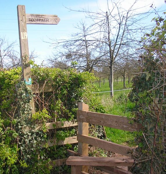
Very shortly on the right, tucked away in the hedgerow a footpath sign indicates the route at map reference SO 70703 38614. After crossing over the only stile of the walk, the footpath heads uphill with a cider apple orchard to the left and the field boundary to the right and further over the railway cutting.
The hedgerow supports a large number of rabbits and wildlife. The path continues uphill into the next field, into view comes the modern looking Frith Wood House owned by the Forestry Commission. Looking back down the route taken, the Bromyard Road Industrial Estate is in the foreground but further on is the impressive Ledbury railway viaduct spanning 372 yards across the flood plane of the Leadon Valley. Carrying on, a short uphill stretch through a small copse leads to a swing gate with a bent bar and then onto a tarmac driveway at map reference SO 71124 38668. The route now heads downhill away from the Forestry Commission ‘no entry sign’.
The panoramic landscape of the Herefordshire countryside and Ledbury Railway Station opens out above the entrance to the 1,323 yard long Ledbury railway tunnel.
The road now joins the busy Knapp Lane. Opposite, there is a footpath leading into Dog Hill Wood. Our intention is to maintain the views across the Leadon Valley and walk across the road. A little to the right is the single lane, no-through road called Upperfields (appropriate name).
The view of Ledbury is enjoyed to the right and the woods are to the left. Soon the tarmac becomes gravel as the road gently heads downhill. The footpath from the woods is now running parallel to the track so deviate a little uphill and continue to follow the footpath, which is adorned with Bluebells in May. Upperfields comes to an abrupt end with a small track heading downhill which is ignored at map reference SO 71225 38637. Our footpath runs parallel with the hedge giving good views across Ledbury. The large fermentation tanks of the Heineken brewery can be seen in the distance plus the rather more attractive facets of Ledbury town in the foreground. A rather scruffy signboard is soon encountered describing the ‘Geology of Dog Hill Wood’.
The path now descends quite steeply and is joined from the left by another from Dog Hill Wood. At the time of the Doomsday Survey this footpath was the original drovers route to Malvern. After a short steep decent, concrete steps lead onto the quiet Church Street. Just before the steps end, on the wall to the left is a small plaque indicating that this was once called ‘Green Lane. The old packhorse route to Worcester’.
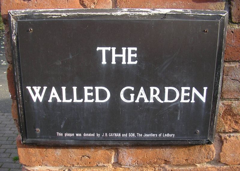
Continue a little way downhill and on the left is the Georgian styled Coach House which is part of the Upperhall Estate. To the left is the small gateway leading into the Walled Garden and the churchyard of Ledbury Parish Church of St Michael and All Angels at map reference SO 71201 38154. However, if you enjoy observing the local history plaques for which there are many in Ledbury, fifty or so meters further down on the right, following the line of an old stone wall is a row of modern houses. On the first house is the interesting round plaque ‘Ants’ Nest Demolished 1973’. The history behind such an unusual name appears to have been recorded in the book ‘Old Ledbury By An Octogenarian’ written by George Wargent in 1889. A carpenter was working on the construction of the original properties and said to the owner of the building company “this will be a regular ants nist gaffer”. From that remark the name has remained ever since. The keen eyed will also notice the original grammatical error with the word Ant’s. The original apostrophe is now over-painted.
Walk back up the road and into the gateway where once there was a swing gate. Take the immediate right archway into the delightful Walled Garden and downhill towards the gate and the remarkable 16th century black and white timbered Church House and the Abbots Lodge dating back to 1480 which was once the vicarage and is next to the walled churchyard in Church Lane. The church is covered in more detail in the Ledbury Town Centre walk.
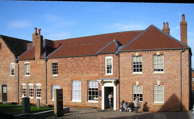
On leaving the secluded Walled Garden the impressive 18th century Georgian style ‘Old Magistrates House’ is slightly off to the right. Look up to see the plaque describing that these buildings were restored in 1987-88. We continue our walk along the original Ledbury to Malvern route down Church Street. Whilst Church Street does not appear on many picture postcards of Ledbury, there is still much of interest to be seen. On the right is the former White Hart public house and the Bowlers Yard 1933 plaque. Just a little further on is an interesting feature with the ‘Ledbury Station brickworks’ brick set at chest height. On the opposite side is the rear of the Prince of Wales public house. The British Legion club and its Union Jack fluttering in the wind is next and on the corner is the information board for the 16th century Painted Room on the early Tudor structure of the Town Council Offices. During restoration in 1989 a number of facinating 16th century wall paintings were discovered. Just a few steps further on brings us to the original crossroads known as Lower Cross next to the Market House. The Upper Cross is now the one-way junction of New Street, the A449 Worcester-Malvern Road next to the imposing Ledbury Park House.
The tall Elizabeth Barrett Browning Institute building built in 1892 is on the opposite side of the road on the corner of Bye Street, which brings us to within shouting distance of our starting point. Thus concluding this short history of public transport inspired excursion around the delightful market town of Ledbury.