Walk 15 - Round The British Camp
British Camp car park to Elgar’s Grave, then onto Little Malvern Priory returning via the summit of British Camp.
Summary
This short but strenuous walk encompasses a fair slice of culture for this sparsely populated section of the Malvern’s. Starting at the large British Camp car park the walk climbs behind the Malvern Hills Hotel passing to the rear of Wynds Point and a plaque commemorating Sir Barry Vincent Jackson. Following a downhill section to the Wells Road, St Wulstans Church is close by where the graves of Edward Elgar and his wife can be found. Continuing south, Little Malvern Priory and Court provide an interesting historical setting. The route continues south gaining height until Broad Down is reached. The final section climbs to the summit of the Herefordshire Beacon probably better known as British Camp before returning on a steep downhill section to the car park.
Distance and time
1.5 hours without rest stops for this circular 3.5 mile walk
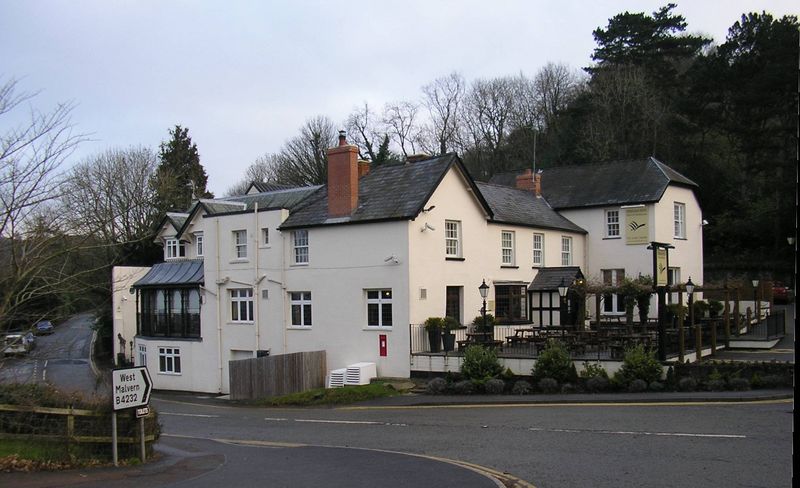
The large Conservators British Camp Car Park is situated at the junction of the A449 Ledbury to Malvern Road and the B4232 West Malvern Road, opposite the Malvern Hills Hotel, map reference SO 7630 4041. If arriving early in the morning the smell of cooked breakfasts at the hotel can be a little disconcerting, but hold true and enjoy gastronomic pleasures later having first earned it with this walk.
Description of the walk:
Spend a few moments to read the information board situated towards the top end of the car park. With the hotel ahead take a route 30 degrees to the right, downhill and on the opposite side of the busy main road there is the Wynds Point Spout. This is located close to the entrance to Wynds Point house. This was the home of the nineteenth century coloratura soprano Jenny Lind, from 1883 until her death in 1887.
Being mindful of the traffic on this busy road, now walk up to the hotel and continue past it as if heading towards West Malvern. Possibly a few diners will view your progress as you walk past the hotel however ignore their envious glances at the pleasure you are getting from the fresh air and exercise! Once past the hotel and its car park there is a well trodden steep path immediately to the right leading uphill. On reaching a small plateau take the path towards the trees, the more acute path to the right leads directly up to the rear of Wynds Point close to an outhouse.
Looking ahead there is a line of four seats facing north overlooking the foothills. Shortly after the second seat there is a metal plaque on a large lump of Malvern stone to Sir Barry Vincent Jackson who directed the Malvern Summer Festival from 1929 to 1937.
The plaque reads:-
These trees and seating commemorates Sir Barry Vincent Jackson 1879 to 1961 who lived nearby, founder of the Birmingham Repertory Theatre and the Malvern Festival, Director of the Royal Shakespeare Memorial Theatre and the Covent Garden Opera Company
‘He nothing common did nor mean’
Sir Barry’s plaque at map reference S0 7648 4030 overlooks the splendid property named after the hill dominating the skyline, Black Hill, he had this built in the late 1920’s.
Continue past the four seats and follow the path into the woods as it circumnavigates the hill behind Wynds Point. Little if any sunshine is able to permeate the canopy of leaves and branches. Our path now meets a track coming up from the Wells Road. A short distance further on, the woodland path now changes direction almost 360 degrees leading away from Wynds Point at map reference SO 7659 4036 in a northerly direction following the contour of the hill.
Continue past the blue painted seat with the inscription ‘In memory of John Roberts. Hills Ranger 1954 to 1975’, a small stone sign indicates the path to the Holy Well and the Wych Crossing at map reference SO 7691 4102. Our route is the large path descending towards the Wells Road. In fact the path leads onto the Holywell Road turning into the Wells Road, map reference SO 7713 4125.
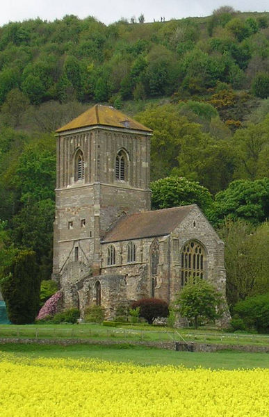
A little further, on is the entrance to St Wulstan’s Church, map reference SO 7707 4100. Walk down the driveway and around the church to the graveyard at the rear. Elgar’s grave is signposted towards the end of the path facing east near the wall of the church. Spend a few moments reading the inscriptions in this beautiful setting before returning to the Wells Road.
Turn left past the impressive Kirklands Home Farm. Observe the impressive stonework. Continue along the Wells Road with the Hills to the right in the direction of the British Camp and then turn down the sharp left-hand bend signposted Upton upon Severn A4104. Approximately a few hundred metres further on down the hill is the historic Little Malvern Court and a few paces further on the gated entrance to Little Malvern Priory map reference SO 7701 4047. On the left-hand side opposite the Priory is a sizable car park.
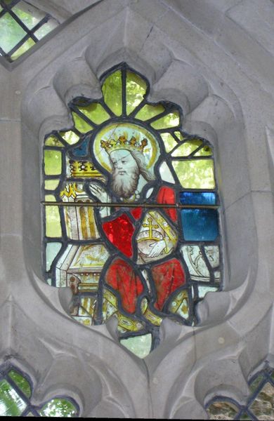
The entrance to the Little Malvern Priory is normally unlocked and access can be gained to the vestibule which contains displays of interesting artefacts and ancient relics. Enter the chapel through the small iron gridded door to the left. The small chapel is quite bright probably due to the majority of the windows being unglazed. The exception being the fifteenth century remains in the large east window. Research indicates that the glazing of the east window has its place in late medieval English history. It dates back 1480 to 1482 and was made in a Malvern workshop led by Richard Twygge and Thomas Woodshave. They produced some of the most influential glazing commissions that were carried out in the 1480’s and early 1500’s which included Great Malvern Priory, Tattershall College, Lincoln and the nave at Westminster Abbey. The glass painted window depicts the key Yorkist personalities in English fifteenth century history with the family of Edward IV and Elizabeth Woodville with the future king Edward V.
The choir seats are original, the hand rests are mostly intact, however, most of the misericords were ripped off a few centuries ago by Oliver Cromwell’s men. The pulpit with its rather foreboding eagle (enough to scare off most children from going to church I would have thought) is Victorian. The framed pictures of the coat of arms associated with the Priory are fascinating. On concluding this visit to the Priory return back up the hill to Little Malvern Court. The Court is only open from mid April to mid July on Wednesdays and Thursday afternoons between 2.15pm and 5.00pm. The admission to the house and gardens is £5.50 and £2.00 for children.
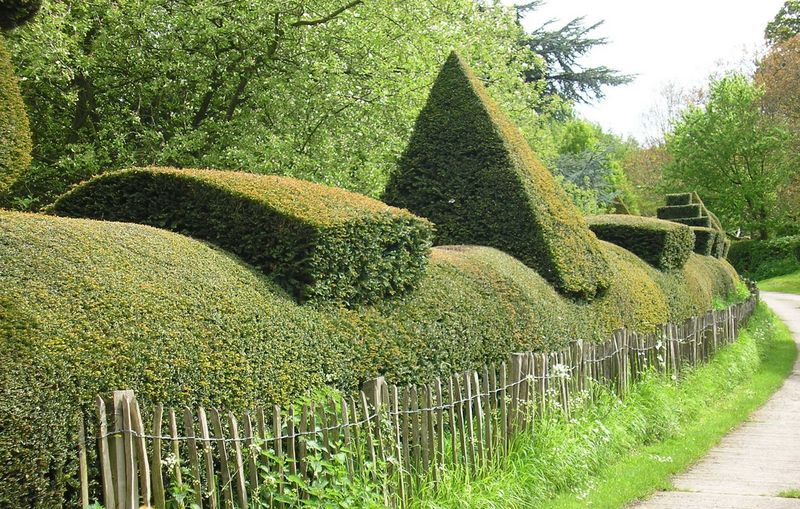
Turn left alongside the Court, map reference SO 7694 4041, continue across the cattle grid and on the left the neatly manicured hedge marking the boundary with sculptured birds and geometric shapes proudly display highly developed toparian skills. A little brook emanating at the Owls Hole Spring further up the hillside emerges from the bank to the right. Also on the same side higher up the hill is a Victorian walled garden.
The far end of the Little Malvern Court gardens have been landscaped with an attractive layered garden with a brook gently flowing through what can be best described as a series of wooden locks into a medium sized pond with a rather large sign indicating ‘No fishing’. Heading out of this little gully the road gains height, giving far reaching views across the Severn Valley. Observe the natural sculpture created by the remains of a large tree and the undulating countryside provides a photographic opportunity.
On the right a galvanised gate and footpath sign hides beside a fir tree as the black and white timbered Underhills Farm just comes into view in the next valley at map reference SO 7695 3983. Pass through the gate, the path leads diagonally across the field up towards Tinkers Hill and into the woods. Continue through an old iron gate where the path ascends up the base of the narrow valley with a stream running alongside. The steep, stony path eventually comes out in the British Camp car park. However our route is to cross over the stream at map reference S0 7670 3977, after following the remains of a stone wall on the right, the path continues around the contour of the hill back to the west with the Severn plain to the left.
The path is easy going, to the left are wooden electricity pylons and a little further on down the field is Dales Hall Farm and the track heading to the Gullet Quarry. To the right at map reference SO 7672 3921, take the path leading up the valley between Hangman’s Hill and Broad Down. The Conservators sign indicates ‘no horse riding’ on this steep woodlands track. Height is quickly gained with the gully narrowing to the right and then at map reference SO 7637 3929 the path heads right, in a northerly direction across the top of the gully and emerges out of the trees onto the sheep-trimmed grass of Broad Down. Numerous paths can be followed up the hill with glorious views opening up over the Severn plain.
Map reference SO 7628 3947 is the summit of this gentle hill, called Broad Down. A stone post in the ground helps identify the summit, and take a bearing on the distant Obelisk on the Herefordshire side of the hill. Look out for the eroded Red Earls Dyke at map reference SO 7624 3937. This man made ditch follows the ridge of the hills and provided the boundaries between the Red Earl of Gloucester who had his castle at Hanley and the Bishop of Hereford. As our route descends to a well defined path, Clutters Cave provides a sheltered watch point for the ancient Britons at the southern end of this impressive hill fort.
Now walk in the direction of British Camp and soon a stone and concrete Toposcope marks the saddle between Broad Down and British Camp. Note the direction of the local landmarks marked on the surface at map reference SO 7622 3949. The impressive ramparts to British Camp are crossed at map reference SO 7609 3950. Continue uphill on the broad path with the glorious views of the undulating Herefordshire countryside to the left with the proud Obelisk protruding like Cleopatra’s Needle.
The summit of British Camp provides extensive views across the three counties on this often windy summit, map reference SO 7597 4004.
Head north from the summit in the direction of the distant Worcestershire Beacon, down the winding path, the last section on approaching the car park is particularly steep and because of its asphalt construction it can be like glass in frosty or icy weather. Returning to the car park the decision whether to rejuvenate tired muscles with a relaxing breakfast or a pint of real ale with lunch at the hotel, is of course entirely yours!
This is an abridged version of a walk from Book Three: A Pictorial Guide to the Malvern Hills, published by Malvern Walks at £8.50. Available in local bookshops like the Malvern Book Co-operative (2 St Anne's Road, Malvern) and Tourist Information Centres in Malvern, Upton Upon Severn, Ledbury, Worcester.