
Walk 5 - In the Shadow of North Hill
Malvern Link to North Hill via Cowleigh. Returning by St Ann’s Well and Great Malvern
By Carl Flint
Summary
A culturally interesting and diverse circular walk of 6.1 miles. Allow a minimum of three hours without refreshment stops. The walk meanders through farmland, cider apple orchards and includes a section of the Worcestershire Way before returning via St Ann’s Well with a refreshing drink of Malvern’s finest spring water, the historic Great Malvern town centre, Elgar’s House and the Link Common. There is also an opportunity to reach the summit of North Hill 1,303 feet (397metres).
The walk begins at Malvern Link Railway Station, which first opened for business in much grander settings in 1859, map reference SO 7820 4741. The only remains of this bygone era are the black-painted wrought iron gates on Platform Two. Leave the station from Platform One and cross the car park past the attractive lamps on Malvern stone entrance pillars and turn left down the Worcester Road, past the building site of the new Fire Station and cross-roads.
On the left is Santler Court; the burgundy coloured plaque depicts the original location of the Morgan Motor Company. H.F.S Morgan opened a garage and motor works here on this site. Continue into the Link and at the junction by the chemist’s shop is the water feature known as the ‘Link Spring’. Turn left into Hampden Road and then through St Matthias churchyard past the Link Stone. This was used to collect dues for the right of passage between the manors of Leigh and Powick. It was moved to St Mathias Church around 1744.
Turn right, down Church Road and then left onto Lower Howsell Road. Go past the playing fields and the New Inn. Note the medieval cottages, such as Cromwell Cottage dating back to circa 1390; several seventeenth century timber-framed buildings provide a post-medieval historical setting. Continue to the railway bridge, take the small footpath just off the brow of the bridge, map reference SO 7868 4897 and turn left parallel to the railway line. Emerging out of a small copse the walk follows the well-trodden path, towards a line of trees. Looking south-west, the full splendour of the northern hills unfolds.
Keep to the footpath beside the hedge and cross over a small footbridge by a pond. During springtime the number of rabbits to be seen along this path is considerable. The path terminates at the metal ‘kissing gate’, map reference SO 7780 4871, in Bronsil Drive. Continue past the modern houses for 50 metres or so into Tanhouse Lane. Turn right, crossing over Whippits Brook. Follow the road around a sweeping left-hand bend and onto the Leigh Sinton Road. Turn right and walk for a few hundred metres and then left into Halfkey Road where it merges into Hospital Road. Go past several culs-de-sac’s and a number of Malvern’s famous gas lamps. The footpath now follows the course of a small brook, continue around the orchard with the hedge to the right. In spring the glorious pink and white apple blossom is well worth seeing. A few hundred metres further on take the large track that crosses the centre of the orchard following the route of the Worcestershire Way, map reference SO 7679 4861.
After the orchard a wooden seat provides the weary with fine views of the valley. Continue through the kissing gate into the open fields following the footpath to our second encounter with Whippits Brook in the lee of several oak trees. This is an excellent picnic spot where children can play in the shallow spring water. Cross the bridge and careful not to trip up on the cattle bars at ankle height, and across the grassy knoll to the next stile; the path leads uphill with the woods to the left into a cider apple orchard. The path disappears into the corner of the woods through a galvanised gate and a short run of steps down onto a farm track providing a viewpoint of End Hill and North Hill. Looking left, here is a glorious view of North Malvern, Malvern Link and in the distance the Severn Valley and the Old Hills at Callow.
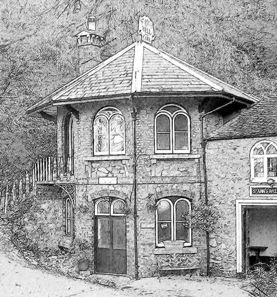
Follow the track downhill and exit through a five barred gate to meet the Cowleigh Road (B4219). Turn left past Cowleigh Park Farm built in 1620, with a history dating back to the thirteenth century, and onto the Cowleigh Spring, officially titled the Earl of Beauchamp Fountain built in 1905 and enjoy the elixir of the Malvern Hills from this prolific fountain at map reference SO 7664 4753. Tucked behind the spring is a small car park with an information board. Continue along the Cowleigh Road and take the right turn up the steep Belvoir Bank leading to the junction with the North Malvern Road, turn left towards the clock tower built in 1843 (map reference SO 7695 4707). The sketch shows the new wrought iron gates and splendidly presented interior during the annual Well Dressing Festival.
Walk a short distance down to the large North Hill Quarry car park and past a couple of houses nestling in the hillside. Further along, the path splits into two; stay with the higher path. On reaching the sign for North Hill, located at ankle height map reference SO 7732 4638 climb the path zigzags, north-south up North Hill, through bright yellow gorse in spring and strikingly purple foxgloves in summer to provide stunning view over Great Malvern. The steep path now joins the wide track named ‘Lady Howard De Walden Drive’.
To enjoy a steep scramble up to the summit of North Hill turn right, and just a short distance further on take the path up the hillside. The path, if viewed from a distance, creates a near vertical scar on the hillside. On reaching the summit the panorama of the counties of Worcestershire and Herefordshire unfold. Either retrace one’s steps to the ‘Drive’ or head west following the largest of the paths down towards the nape of Green valley to a conveniently located bench.
The ‘Drive’ dominates the route around North Hill above the attractive Green Valley, as it meets the top of the valley it joins the junction of a number of paths, map reference SO 7672 4598. To continue straight on here, will lead to the ‘Saddle’, the point between Sugarloaf Hill 1,207feet (368metres) and the Worcestershire Beacon. Follow the sign to Great Malvern down the sycamore tree lined Green Valley. Continue downhill and take the right fork to St Ann’s Well. However, before doing so, just a few metres straight on from the junction there is a grassy plateau known as St Ann’s Delight, map reference SO 7719 4585; here is a seat, picnic area and fine views of Malvern.
Now head down to St Ann’s Well where one can enjoy a well-earned rest after covering 3.7 miles of this walk, possibly sampling some freshly cooked vegetarian food. Inside the building above the sculptured well basin and spout is an inscription recounting that St Ann was the mother of Mary, the mother of Jesus. Judge for yourself whether Tolkien a frequent visitor here gained inspiration and imagined the small rounded building nestling amongst the trees and hillside as a burrow for his hobbits!
Take the steep downhill track towards Great Malvern. On reaching the junction of the path and sign marked ‘Halfway’, take a right, tucked in the corner is the public footpath which descends for some 97 steps (rather than the stated 99) to the pleasant Rosebank Gardens. Count them for yourself and make up your own mind? Note the plaque to the memory of Sir Edward Elgar, 1857-1934. Walking down the path beside the wall to the Mount Pleasant Hotel the Wells Road is reached; on the right is an attractive Victorian bus stop. Local buses to Barnards Green, Ledbury and National Express coaches to London stop here.
Turn left and cross over the road towards the famous Victorian developed Belle Vue Terrace then down the steps to the splendid Malvhina Fountain. This is the central and most accessible spring in Great Malvern and is the finishing point of the Worcestershire Way. Continue past the information board to Elgar’s statue. Looking across Church Street is Malvern’s premier purveyor of beverages and light lunches, the Blue Bird Tea Rooms. Head out of Belle Vue Island by walking down the steps opposite the Post Office, then turn left, cross the road and continue uphill past the Tea Rooms. Straight ahead is Barclays Bank, housed in an impressive building, which was the Royal Library in the 1900’s.
On the opposite side is ‘The Unicorn’, which is reputed to be Malvern’s oldest public house. It is said that C.S. Lewis enjoyed a pint or two of the local brew here, and after one of his sojourns to this hostelry one evening, he noticed the inviting glow of the gas lamp on the main road, which gave him the inspiration for the entrance to Narnia.
The Foley Arms Hotel is a short distance along the Worcester Road, followed by seven splendid Regency period houses. Number 44, is Montreal House where Charles Darwin made his second visit to Malvern for the water cure for his daughter and himself under the supervision of Dr James Gully, and where sadly his daughter Anne died. The blue plaque was placed on the gatepost in 2009 to commemorate the bicentenary of the birth of Darwin. Anne is buried in Malvern Priory.
Continue for a few hundred metres and take the right turn down the steep Bank Street, crossing into Zetland Road and onto the junction to one of Malvern’s finest watering holes, the Nag’s Head. This has been voted CAMRA’s top pub in the UK on a number of occasions. Map reference SO 7767 4689. Head uphill from the Nag’s Head to Moorlands Road and then, taking care at this busy corner of the Worcester Road known as Link Top, cross over by the general stores and head downhill a short distance to Alexandra Road. Many of the houses here date back to the 1700’s and are quite impressive. Number 37, ‘Forli’ is 300 m on the left and set back from the road. The only evidence of this historic house is the small plaque on the pillar of the garden wall where Elgar wrote the Enigma Variations and Imperial March between 1889 and 1898.
Retrace one’s steps back to the Worcester Road and enjoy the gentle downhill perambulation towards Malvern Link. Further down is the elaborate white stone Temperance Drinking Fountain built in 1900. The other interesting Victorian artefact located on the opposite side of the road, is the red painted cast-iron post-box. A short distance down the Worcester Road past the hospital is Malvern Link station and the conclusion to this historically charged circular walk.
This is an abridged version of the walk, taken from the Pictorial Guide to the Malvern Hills Book 1. ISBN 978 0956629500, published by Malvern Walks £7.95. Available in local bookshops like the Malvern Book Co-operative (2 St Anne's Road, Malvern) and Tourist Information Centres in Malvern, Upton Upon Severn, Ledbury, Worcester.
For further information, updates and comments, please contact Carl at info@malvernwalks.co.uk